Workboat Passage
- Saltwater
- Strait
Workboat Passage
- Saltwater
- Strait
- Sq. miles
- 14
- Boat Ramps
- 0
- Access Points
- 0
- Species
- 0
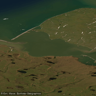
Workboat Passage is a shallow, dynamic saltwater strait separating Herschel Island-Qikiqtaruk from the mainland coast of Ivvavik National Park in the Yukon's Inuvialuit Settlement Region. This narrow passage, approximately 2 kilometers wide, serves as a vital travel route and ecological corridor in the western Arctic. The waters are notably shallow, generally less than 3 meters deep, and are influenced by strong longshore currents. The surrounding landscape is low-lying and treeless, characterized by spits, shoals, and gravel beaches, with the environment constantly reshaped by coastal erosion, ice, and the transport of driftwood from the Mackenzie River. The area holds profound cultural significance, with a long history of Inuvialuit use for seasonal hunting and fishing, evidenced by archaeological sites like those on Avadlek Spit. The passage lies within a complex jurisdictional area bordering a National Historic Site, a territorial park, and a national park, emphasizing its protected status.
Species & education
Learn what type of fish are at Workboat Passage and what's needed to catch them.
No species information available.
Fishing spots, boat ramps & amenities
Learn how to get on Workboat Passage. Uncover great fishing access points, boat ramps, and all the facilities you need for an unforgettable day on the water. Some locations shown may border or include private property. Always check property boundaries and applicable regulations before visiting. onWater's Public & Private Land layer can help you plan your access with confidence.
Avadlek Spit, a nearly 5-kilometer-long gravel spit at the west end of Workboat Passage, is a known good fishing spot. The shallow waters and shoals throughout the passage, particularly around the series of unnamed islands and sandbars that are periodically exposed at low tide, create natural fish-holding structure. The eastern entrance to the passage is also highlighted as a key area of ecological importance.
Know where you can legally fish on Workboat Passage
See public and private land boundaries along the water, turn on private parcels with owner details to know where permission is required, and find land-trust parcels that offer permitted fishing access.
Yt licenses and regulations
No licenses or regulations available for Yt.
Take Workboat Passage with you
The onWater Fish app keeps this water's access points, species and conditions in your pocket, with the tools you use once you're there.
Use the map without signal
Download the map around Workboat Passage to use it offline when coverage drops.
Log your catches here
Keep a private fishing journal for Workboat Passage to find where and when fish are biting for you.
Get the onWater Fish app
Free on iOS and Android
Tides, wind & water conditions (10 day forecast)
On open water, wind and tide matter as much as the weather. See the best times to fish Workboat Passage and check the marine forecast before you launch.
Loading tide predictions…
Fishing near Workboat Passage
Explore Yt waters
Top fishing waters
No waters available right now.
Popular Cities
Loading popular cities...
Explore near Workboat Passage

Smarter Fishing Starts in the App.
onWater Fish gives you everything you need to plan smarter, fish better, and own every trip from first cast to last.