Horn Island Pass
- Saltwater
- Pass
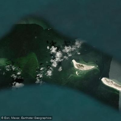
Horn Island Pass
- Saltwater
- Pass
- Sq. miles
- 18
- Boat Ramps
- 0
- Access Points
- 0
- Species
- 10
Horn Island Pass is a significant tidal pass located in the Mississippi Sound, separating Horn Island from Petit Bois Island off the coast of Jackson County. This dynamic saltwater environment connects the protected waters of the sound with the open Gulf of Mexico, creating a major conduit for tidal flow and fish movement. The pass is adjacent to the federally maintained Pascagoula Ship Channel, which sees significant commercial vessel traffic. The surrounding waters are part of the Gulf Islands National Seashore, offering a wilderness fishing experience characterized by clear Gulf waters on the south side and shallower, often murkier sound waters on the north. The area is renowned for its diverse inshore and nearshore fishery, with structure provided by the natural sand composition of the pass and the adjacent islands.
Species & education
Learn what type of fish are at Horn Island Pass and what's needed to catch them.

Find which waters have the species you want to catch

Black Drum
Pogonias cromis

Blacktip Shark
Carcharhinus limbatus

Blue Runner
Caranx crysos

Bluefish
Pomatomus saltatrix

Ladyfish
Elops saurus

Red Snapper
Lutjanus campechanus

Redfish
Sciaenops ocellatus

Sheepshead
Archosargus probatocephalus

Spanish Mackerel
Scomberomorus maculatus

Spotted Seatrout
Cynoscion nebulosus
Fishing spots, boat ramps & amenities
Learn how to get on Horn Island Pass. Uncover great fishing access points, boat ramps, and all the facilities you need for an unforgettable day on the water. Some locations shown may border or include private property. Always check property boundaries and applicable regulations before visiting. onWater's Public & Private Land layer can help you plan your access with confidence.
Wreck
Wreck
Wreck
Wreck

Wreck

Wreck
Wreck
Wreck
Wreck
Wreck
Know where you can legally fish on Horn Island Pass
See public and private land boundaries along the water, turn on private parcels with owner details to know where permission is required, and find land-trust parcels that offer permitted fishing access.
Mississippi licenses and regulations

Mississippi Boating Regulations
When using any type of watercraft to access a body of water, it is important to follow all federal, state, and local rules and regulations. These rules and regulations include boat permitting and licensing, invasive species inspections and stamps, life jacket and PFD rules, motor size and horsepower restrictions, noise limitations, restrictions on personal watercraft, and many more. Visit the web link below for the most current rules and regulations for this body of water.

Mississippi Coastal & Inland Waters
Mississippi divides its coastal waters using Highway 90 and Interstate 10 as licence boundary markers. South of Highway 90 requires a saltwater licence; between Highway 90 and Interstate 10 either a saltwater or freshwater licence is accepted; north of Interstate 10 a freshwater licence applies. The Mississippi Department of Marine Resources administers saltwater licensing for the coastal zone.

Mississippi Federal Waters & Offshore Rules
Once you move beyond state waters into federal waters, NOAA Fisheries and the Gulf of Mexico Fishery Management Council set the rules. Anglers fishing for highly migratory species such as tunas and billfish anywhere must obtain an Atlantic highly migratory species permit from NOAA Fisheries. The MDMR also notes that federal regulations continue to apply in the extended state boundary area and recommends anglers comply with both.

Mississippi Saltwater Fishing License
A saltwater fishing license from the Mississippi Department of Marine Resources covers the marine waters south of Highway 90, for residents and nonresidents alike. Between Highway 90 and Interstate 10 either a saltwater or a freshwater license is accepted, and north of Interstate 10 a freshwater license from the Department of Wildlife, Fisheries and Parks applies.

Mississippi Saltwater Size & Bag Limits
Size and bag limits apply per species and can change through the year for Mississippi saltwater fishing. The Mississippi Department of Marine Resources sets these rules, covering species such as red snapper, gag grouper, flounder, cobia and red drum. The current limits table is maintained by the MDMR at the link below.

Mississippi Shellfish Closures & Advisories
Recreational oyster, shrimp and crab harvesting in Mississippi coastal waters requires separate licences issued by the Mississippi Department of Marine Resources. Specific harvest areas open and close throughout the season based on water quality, management orders and other conditions, with closures posted by the MDMR. Check the MDMR shellfish pages for current open areas, maps and any active closures before heading out.
Take Horn Island Pass with you
The onWater Fish app keeps this water's access points, species and conditions in your pocket, with the tools you use once you're there.
Use the map without signal
Download the map around Horn Island Pass to use it offline when coverage drops.
Log your catches here
Keep a private fishing journal for Horn Island Pass to find where and when fish are biting for you.
Get the onWater Fish app
Free on iOS and Android
Tides, wind & water conditions (10 day forecast)
On open water, wind and tide matter as much as the weather. See the best times to fish Horn Island Pass and check the marine forecast before you launch.
Loading tide predictions…
Fishing near Horn Island Pass

Pascagoula River
Black Creek
Mississippi Sound
Leaf River
West Pascagoula River
Grand Bay
McInnis Bayou
Explore Mississippi waters
Top fishing waters
Popular Cities
Loading popular cities...
Explore near Horn Island Pass
Fish species
Nearby waters
More in Mississippi

Smarter Fishing Starts in the App.
onWater Fish gives you everything you need to plan smarter, fish better, and own every trip from first cast to last.