St. Margarets Bay
- Saltwater
- Bay
St. Margarets Bay
- Saltwater
- Bay
- Sq. miles
- 47
- Boat Ramps
- 0
- Access Points
- 0
- Species
- 18
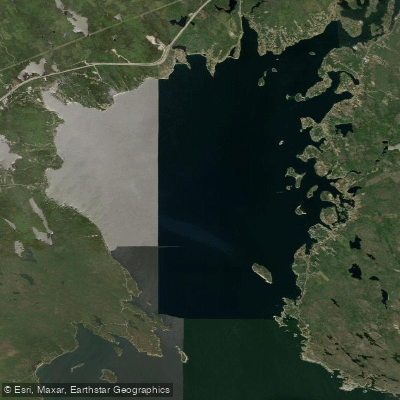
St. Margarets Bay is a picturesque coastal inlet on the South Shore of Nova Scotia, located approximately 40 kilometers west of Halifax. Encompassing an area of 70 square kilometers, this bay is a significant marine environment characterized by its relatively warm surface waters, sheltered coves, rugged granite islands, and sandy beaches. The bay's counterclockwise circulation pattern helps flush its waters every 10 to 30 days, contributing to its productivity. Historically and presently, fishing remains the primary industry, supporting both commercial operations and a vibrant recreational angling scene. The region is a popular summer resort area and hosts a sizable tourist trade, with iconic locations like Peggy's Cove drawing visitors. For anglers, the bay offers diverse inshore and nearshore saltwater fishing opportunities in a setting of pristine natural beauty.
Species & education
Learn what type of fish are at St. Margarets Bay and what's needed to catch them.

Find which waters have the species you want to catch

Acadian Redfish
Sebastes fasciatus

American Plaice
Hippoglossoides platessoides

Atlantic Bluefin Tuna
Thunnus thynnus

Atlantic Cod
Gadus morhua

Atlantic Herring
Clupea harengus

Atlantic Mackerel
Scomber scombrus

Atlantic Tomcod
Microgadus tomcod

Atlantic Wolffish
Anarhichas lupus

Blue Shark
Prionace glauca

Monkfish
Lophius americanus

Pollock
Pollachius virens

Spiny Dogfish
Squalus acanthias
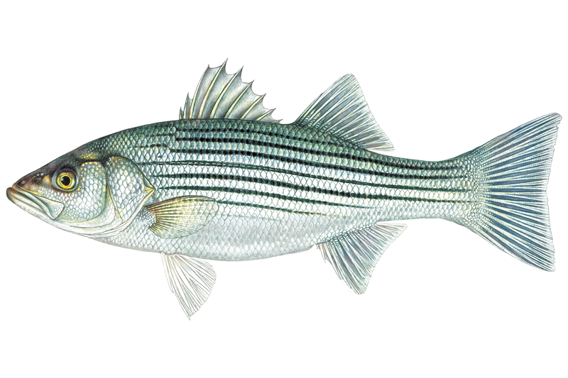
Striped Bass
Morone saxatilis

Thorny Skate
Amblyraja radiata

White Hake
Urophycis tenuis

Winter Flounder
Pseudopleuronectes americanus

Witch Flounder
Glyptocephalus cynoglossus

Yellowtail Flounder
Limanda ferruginea
Fishing spots, boat ramps & amenities
Learn how to get on St. Margarets Bay. Uncover great fishing access points, boat ramps, and all the facilities you need for an unforgettable day on the water. Some locations shown may border or include private property. Always check property boundaries and applicable regulations before visiting. onWater's Public & Private Land layer can help you plan your access with confidence.
Productive fishing is often associated with the bay's varied structure. Sheltered coves and the areas around the many granite islands can hold fish. The vicinity of Hubbards is a noted location where anglers have successfully caught species like butterfish and mackerel. Areas with deeper water near channels and drop-offs are worth prospecting for pollock and cod. The presence of marine wildlife like seals and dolphins can sometimes indicate baitfish concentrations and predatory fish.
Know where you can legally fish on St. Margarets Bay
See public and private land boundaries along the water, turn on private parcels with owner details to know where permission is required, and find land-trust parcels that offer permitted fishing access.
Ns licenses and regulations

Nova Scotia Boating Regulations
This page explains what a Pleasure Craft License is, who needs one, how to apply for one, and how to keep your information up to date.

Nova Scotia Fishing License
Official Government of Nova Scotia page to learn about and buy a recreational sportfishing (General Fishing) licence — who needs one, licence types (seasonal and 1-day), fees, and how to apply online or through vendors.

Nova Scotia Fishing Regulations
Nova Scotia's official recreational sportfishing laws and regulations, linking the current Anglers' Handbook and the Maritime Provinces Fishery Regulations covering seasons, bag and size limits, gear rules, and where you can fish.
Take St. Margarets Bay with you
The onWater Fish app keeps this water's access points, species and conditions in your pocket, with the tools you use once you're there.
Use the map without signal
Download the map around St. Margarets Bay to use it offline when coverage drops.
Log your catches here
Keep a private fishing journal for St. Margarets Bay to find where and when fish are biting for you.
Get the onWater Fish app
Free on iOS and Android
Tides, wind & water conditions (10 day forecast)
On open water, wind and tide matter as much as the weather. See the best times to fish St. Margarets Bay and check the marine forecast before you launch.
Loading tide predictions…
Fishing near St. Margarets Bay
Explore Ns waters
Top fishing waters
No waters available right now.
Popular Cities
Loading popular cities...
Explore near St. Margarets Bay
Fish species
Nearby waters
More in Ns

Smarter Fishing Starts in the App.
onWater Fish gives you everything you need to plan smarter, fish better, and own every trip from first cast to last.