When you're heading out for a day on the water, guessing isn’t part of good planning. We've all been there, following a map to a “public access point” only to find a sketchy pull-off, unclear trails, or no parking in sight. That uncertainty can turn a fishing trip into a bad experience.
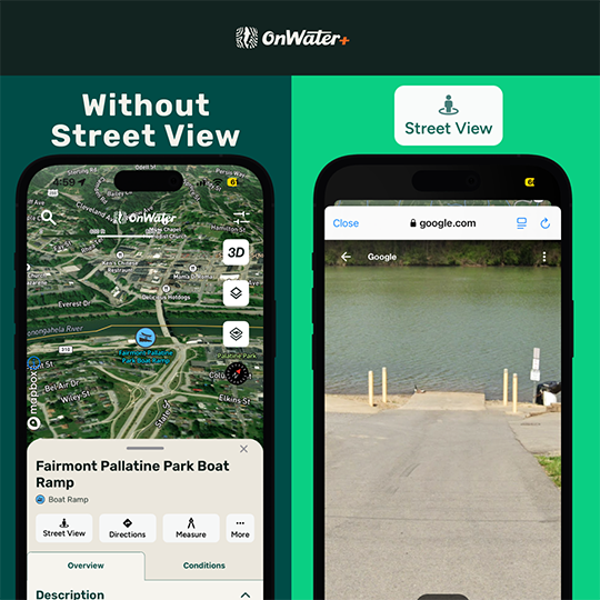
That’s why we introduced Street View for Fishing Access Points in the OnWater Fish App. It’s a simple tool with serious value. It gives you a real-world preview of select access spots so you know exactly what to expect before you ever leave home.
Why Do I Need Street View?
Getting to the water shouldn’t be the hardest part of your day. With Street View, you can:
- Preview Parking
It sounds simple, but parking can make or break your day before you even rig up. Many fishing access points, especially on rivers and remote lakes, don’t have paved lots or clear signage. You could be dealing with a narrow pull-off on the side of a dirt road, a single muddy turnout, or a spot already packed by mid-morning. - Prepare For Launch
Not all boat ramps are created equal. Some are paved and maintained, others are little more than a slope of gravel labeled “unimproved.” If you're hauling a drift boat, kayak, or raft, knowing what you’re dealing with is critical.
Street View lets you check the condition and layout of the ramp before you commit. Is it steep? Soft? Washed out? Will you need four-wheel drive to get out? You can also see if there’s enough space to stage gear or turn around, things a map pin won’t tell you.
- Know What the Walk-In Looks Like
Some of the best fishing spots don’t come with a boat ramp or a clear path. Wading access often means navigating unmarked trails, dense woods, or unexpected obstacles between you and the river.
With Street View, you can preview what the walk to the water might look like before you lace up your boots. Is it a short path or a bushwhack through thick brush? Are you dealing with downed trees, fences, or a soggy swamp? A quick preview helps you prepare.

- Confirm you’re in the right spot
With Street View, you can visually confirm landmarks, gates, signage, or pull-offs so you know you’re exactly where you’re supposed to be. Recognize the spot right away instead of circling around or wondering if you missed the turn.
How to Use Street View in the OnWater Fish App
Using Street View is simple:
- Tap on a fishing access point and look for the Street View icon
- Preview the access to see parking, pull-offs, trails, or ramps based on what is available at that spot

Tap to start your free trial of onWater+.
If Street View is not available, you can still get detailed access data, public land boundaries, and more in the app.
Fish Smarter.
Get street smart before your next trip.
Start your free 7-day trial of OnWater+ to scout access points with Street View, find new waters, check conditions, and journal every trip.