Patawalonga Creek
- Saltwater
- Estuary
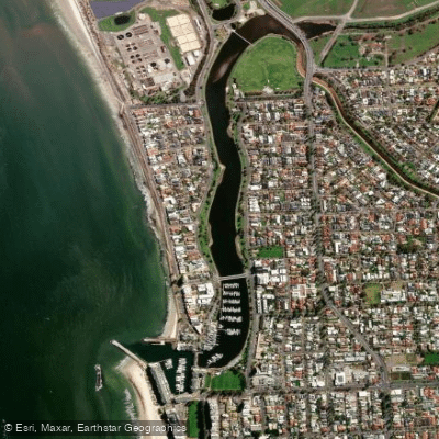
Patawalonga Creek
- Saltwater
- Estuary
- Sq. miles
- 0.1
- Boat Ramps
- 0
- Access Points
- 0
- Species
- 9
The Patawalonga Creek is a tidal river and estuary system located in the western suburbs of Adelaide, within the City of Holdfast Bay. It flows into the Patawalonga Basin, a managed lake system that ultimately discharges into Gulf St. Vincent. The creek forms part of a broader urban catchment, receiving flows from several other waterways including the Sturt River and Brown Hill Creek. Historically a natural creek, significant engineering works have transformed its mouth with lock gates and sheet piling to create the modern Patawalonga Lake, separating it from the sea. The surrounding area features a mix of urban development, recreational spaces, and remnants of native vegetation, including Swamp Paperbark and Kangaroo Honey-myrtle communities, which provide important habitat within the metropolitan coastline.
Species & education
Learn what type of fish are at Patawalonga Creek and what's needed to catch them.

Find which waters have the species you want to catch

Australian Herring
Arripis georgianus

Black Bream
Acanthopagrus butcheri

King George Whiting
Sillaginodes punctatus

Mulloway
Argyrosomus japonicus

Sand Flathead
Platycephalus bassensis

Silver Trevally
Pseudocaranx dentex

Snook
Sphyraena novaehollandiae

Western Australian Salmon
Arripis truttacea

Yellowfin Whiting
Sillago schomburgkii
Fishing spots, boat ramps & amenities
Learn how to get on Patawalonga Creek. Uncover great fishing access points, boat ramps, and all the facilities you need for an unforgettable day on the water. Some locations shown may border or include private property. Always check property boundaries and applicable regulations before visiting. onWater's Public & Private Land layer can help you plan your access with confidence.
Know where you can legally fish on Patawalonga Creek
See public and private land boundaries along the water, turn on private parcels with owner details to know where permission is required, and find land-trust parcels that offer permitted fishing access.
South Australia licenses and regulations

South Australia Boating Regulations
Official Marine Safety SA page on recreational boating rules, covering boat operator licensing, navigation rules, speed and waterway zones, and required safety equipment under the Harbors and Navigation Regulations 2009.

South Australia Fishing License
South Australia has no general recreational fishing licence - most recreational fishing is open without a permit or fee. Registration is only needed for specific cases (e.g. a registered net or rock lobster pot). This official PIRSA Fisheries Licensing page explains when registration applies.

South Australia Fishing Regulations
Official PIRSA recreational fishing rules covering size, bag, boat and possession limits for marine and freshwater species, applied per 24-hour period. See the page for current limits.

South Australia Stream Access Laws
South Australia has no dedicated recreational stream-access statute page; this is the closest official coverage - the Law Handbook SA Water chapter explaining the legal framework for watercourses, water access and adjoining land rights.
Take Patawalonga Creek with you
The onWater Fish app keeps this water's access points, species and conditions in your pocket, with the tools you use once you're there.
Use the map without signal
Download the map around Patawalonga Creek to use it offline when coverage drops.
Log your catches here
Keep a private fishing journal for Patawalonga Creek to find where and when fish are biting for you.
Get the onWater Fish app
Free on iOS and Android
Tides, wind & water conditions (10 day forecast)
On open water, wind and tide matter as much as the weather. See the best times to fish Patawalonga Creek and check the marine forecast before you launch.
Loading tide predictions…
Fishing near Patawalonga Creek
Sturt River
Port River
Henley Beach
Onkaparinga River
Brownhill Creek
Tennyson Beach
Dry Creek
River Torrens
Grange Beach
Karrawirra Parri (River Torrens)
Explore South Australia waters
Top fishing waters
No waters available right now.
Popular Cities
Loading popular cities...
Explore near Patawalonga Creek
Fish species
Nearby waters
More in South Australia

Smarter Fishing Starts in the App.
onWater Fish gives you everything you need to plan smarter, fish better, and own every trip from first cast to last.