Cato River
- Saltwater
- Estuary
Cato River
- Saltwater
- Estuary
- Sq. miles
- 19
- Boat Ramps
- 0
- Access Points
- 0
- Species
- 1
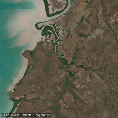
The Cato River is a tidal estuary system flowing into Arnhem Bay within the remote East Arnhem Land region of Australia's Northern Territory. This fertile riverine environment is situated on Aboriginal land and offers a culturally immersive and adventurous fishing experience characterized by its pristine, undeveloped landscape and significant populations of iconic Australian sportfish. Access is managed through a traditional owner-run camping operation and requires specific permits, emphasizing the importance of respecting Indigenous land rights and protocols. The river's environment presents unique challenges, including extreme tropical heat, humidity, and the ever-present danger of large saltwater crocodiles, demanding careful planning and vigilance from visiting anglers.
Species & education
Learn what type of fish are at Cato River and what's needed to catch them.

Find which waters have the species you want to catch

Barramundi
Lates calcarifer
Fishing spots, boat ramps & amenities
Learn how to get on Cato River. Uncover great fishing access points, boat ramps, and all the facilities you need for an unforgettable day on the water. Some locations shown may border or include private property. Always check property boundaries and applicable regulations before visiting. onWater's Public & Private Land layer can help you plan your access with confidence.
The river mouth, where the Cato River flows into Arnhem Bay, is a recognized productive area for fishing. The broader Arnhem Bay area itself is known for fertile fishing grounds. Underwater structures typical of productive barramundi habitat—such as submerged logs, mangrove roots, rock bars, and changes in depth—are present throughout the tidal river sections.
Know where you can legally fish on Cato River
See public and private land boundaries along the water, turn on private parcels with owner details to know where permission is required, and find land-trust parcels that offer permitted fishing access.
Northern Territory licenses and regulations

Northern Territory Boating Regulations
Official NT recreational boating safety guide. Boats need no registration and operators need no licence, but must follow the Marine Act 1981 and Marine (General) Regulations 2013, including minimum safety-equipment requirements.

Northern Territory Fishing License
The Northern Territory does not require a recreational fishing licence - fishing is licence-free, and no recreational boat licence is needed either. This official NT Fisheries page confirms no licence is required and outlines the rules that still apply.

Northern Territory Fishing Regulations
Official NT page setting recreational possession limits, including a general personal possession limit, separate limits for exempt species, and per-vessel limits. See the page for current numbers.

Northern Territory Stream Access Laws
NT has no single generic stream-access statute; the major access consideration is that much of the NT's intertidal waters overlie Aboriginal land. Permission is required to enter intertidal waters over Aboriginal land, and recreational fishers must register (via the Northern Land Council) to access some waters.
Take Cato River with you
The onWater Fish app keeps this water's access points, species and conditions in your pocket, with the tools you use once you're there.
Use the map without signal
Download the map around Cato River to use it offline when coverage drops.
Log your catches here
Keep a private fishing journal for Cato River to find where and when fish are biting for you.
Get the onWater Fish app
Free on iOS and Android
Tides, wind & water conditions (10 day forecast)
On open water, wind and tide matter as much as the weather. See the best times to fish Cato River and check the marine forecast before you launch.
Loading tide predictions…
Explore Northern Territory waters
Top fishing waters
No waters available right now.
Popular Cities
Loading popular cities...
Explore near Cato River
Fish species
More in Northern Territory

Smarter Fishing Starts in the App.
onWater Fish gives you everything you need to plan smarter, fish better, and own every trip from first cast to last.