Tabourie Lake
- Saltwater
- Estuary
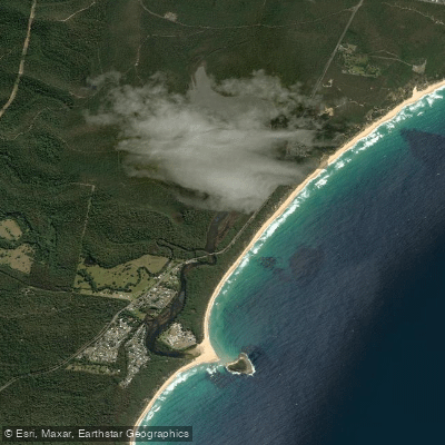
Tabourie Lake
- Saltwater
- Estuary
- Sq. miles
- 1.6
- Boat Ramps
- 0
- Access Points
- 0
- Species
- 3
Tabourie Lake is a coastal estuary, or Intermittently Closed and Open Lake and Lagoon (ICOLL), located south of Ulladulla on the New South Wales South Coast. This tranquil, brackish water body is characterized by its connection to the ocean through a dynamic sand barrier at its entrance. The lake's water levels and salinity are governed by natural processes, with the entrance typically closed by wave action and only opened artificially by Shoalhaven City Council when water levels reach a predetermined trigger to prevent flooding of low-lying areas. This creates a unique estuarine environment that transitions between closed lagoon and open tidal inlet conditions. The surrounding area offers unspoiled beach and lake frontage, with a mix of natural foreshore and residential development along its canals.
Species & education
Learn what type of fish are at Tabourie Lake and what's needed to catch them.

Find which waters have the species you want to catch

Australian Salmon
Arripis trutta

Samson Fish
Seriola hippos

Yellowtail Kingfish
Seriola lalandi
Fishing spots, boat ramps & amenities
Learn how to get on Tabourie Lake. Uncover great fishing access points, boat ramps, and all the facilities you need for an unforgettable day on the water. Some locations shown may border or include private property. Always check property boundaries and applicable regulations before visiting. onWater's Public & Private Land layer can help you plan your access with confidence.
Key areas include the entrance channel, which acts as a funnel for fish moving in and out of the lake. The canals and residential lake frontages provide sheltered water with boat moorings and edges that hold structure. The upper creek sections near Short Street offer access to shallower, weedy areas. The main lake basin holds deeper water and drop-offs. Underwater structure likely includes sand flats, reed beds, and the edges of the dredged canals.
Know where you can legally fish on Tabourie Lake
See public and private land boundaries along the water, turn on private parcels with owner details to know where permission is required, and find land-trust parcels that offer permitted fishing access.
New South Wales licenses and regulations

New South Wales Boating Regulations
Official Transport for NSW (NSW Maritime) hub for safety and rules on NSW waterways, including the Boating Handbook, lifejacket and safety-equipment requirements, and navigation and speed rules.

New South Wales Fishing License
Official Service NSW page for the NSW recreational fishing fee/licence. Anyone fishing NSW waters (fresh or salt) must pay the recreational fishing fee and carry the receipt unless exempt. See the page for current fees and exemptions.

New South Wales Fishing Regulations
Official NSW DPIRD Fisheries hub for recreational fishing rules, covering saltwater and freshwater bag and size limits, possession limits, gear rules and closures.

New South Wales Stream Access Laws
Official NSW DPIRD Fisheries Angler Access page - NSW's closest equivalent to a stream-access page. Explains the public right to fish tidal waters, legal stream access via public land, and that crossing private land needs the owner's permission.
Take Tabourie Lake with you
The onWater Fish app keeps this water's access points, species and conditions in your pocket, with the tools you use once you're there.
Use the map without signal
Download the map around Tabourie Lake to use it offline when coverage drops.
Log your catches here
Keep a private fishing journal for Tabourie Lake to find where and when fish are biting for you.
Get the onWater Fish app
Free on iOS and Android
Tides, wind & water conditions (10 day forecast)
On open water, wind and tide matter as much as the weather. See the best times to fish Tabourie Lake and check the marine forecast before you launch.
Loading tide predictions…
Fishing near Tabourie Lake

Murrumbidgee River

Molonglo River

Queanbeyan River

Cotter River
Ginninderra Creek
Yass River
Goodradigbee River
Paddy's River
Valley Creek

Googong Reservoir
Explore New South Wales waters
Top fishing waters
No waters available right now.
Popular Cities
Loading popular cities...
Explore near Tabourie Lake

Smarter Fishing Starts in the App.
onWater Fish gives you everything you need to plan smarter, fish better, and own every trip from first cast to last.